Please select your home edition
Edition
Crewsaver 2021 Safetyline LEADERBOARD

The hurricanes headed for Hawaii and Florida

by J. Weston Phippen - The Atlantic on 4 Sep 2016
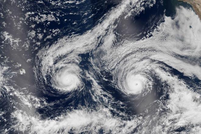
Tropical storm Madeline and hurricane Lester. NASA http://www.nasa.gov
The National Weather Service has upgraded a tropical storm headed for Florida to hurricane status. The first of two hurricanes headed toward Hawaii lost strength and was downgraded to a tropical storm. Meanwhile, in Florida, a tropical storm gained in strength and is now designated as a hurricane.

In Hawaii, Hurricane Madeline slowed to 70 miles per hour as it approached within 75 miles southeast of Big Island. Right behind it came Hurricane Lester, threatening the Pacific island chain with back-to-back storms. Lester is expected to hug the north side of the island, and even if it doesn’t directly hit land, it will bring lots of rain. On Wednesday, rains fell at a rate of one to two inches per hour, and the National Weather Service has extended a flash-flood advisory.

Hurricanes around Hawaii are rare. The ocean waters surrounding the island chain usually aren’t warm enough to give air the uplift it needs to form a hurricane. Even more unusual is a hurricane that strikes the island. Since 1949, just three hurricanes have made landfall, and only 13 hurricanes have come within 200 nautical miles of Hawaii. Add to that the odd occurrence of two hurricanes forming so closely together (even though one has been downgraded) and it has made for an exceptional event.

As for Florida, the governor has declared a state of emergency as Hurricane Hermine approaches. Its wind speed reached 75 miles per hour Thursday afternoon. Here’s a look at its projected path:


Unlike Hawaii, Florida sees plenty of hurricanes in the surrounding Gulf Coast waters. But the state hasn’t had a landfall for 11 years. The last hurricane to strike Florida was Wilma, in 2005, with a sustained wind speed of 175 miles per hour. As of Thursday afternoon, Hermine was 115 miles southwest of Apalachicola, which is near where Wilma hit.

Florida’s Governor declared a state of emergency on Wednesday, pre-empting the hurricane’s landfall. Already, storms have dumped 20 inches of rain in some parts of the state. Schools closed down Thursday, and some people woke up to flooded homes.

J Composites J/99Hyde Sails 2022 One Design FOOTERMarine Products Direct 2023 - Calypso FOOTER

Related Articles

Atlantic Ocean outlook
There has been a worrying increase in reports of GPS jamming The authors of the Norwegian Cruising Guide are now offering Volume 1 as a free Online Book.
Posted today at 2:23 pm
Back in Stock: Henri-Lloyd Elite Jacket and Hi-Fit
Excels in extended conditions, crafted for year-round performance Born from 7 decades of know-how and engineered from ultra-reliable and incredibly durable 3-layer DRI PRO Fabric. The Elite Series has been built for sailing pros and enthusiasts and it excels in extended conditions, crafted for year-round performance.
Posted on 5 May
Restore an Old Sailboat Contest
Hundreds of old sailboats are lying in wait, or are already undergoing loving restorations The Restore an Old Sailboat Contest is back and you have about two months to share your mad skills! We can't wait to see your projects and the results of your hard work.
Posted on 5 May
Pacific Ocean outlook
It seems that thefts from boats at anchor is an on-going problem Cruiser Melissa White has reported security concerns in La Cruz and Punta Mita, Mexico. It seems that thefts from boats at anchor is an on-going problem in this area, and cruisers should be cautious and lock up when going ashore and at night.
Posted on 5 May
DCA has a full programme of rallies for 2024
Dinghy cruising around rivers, lakes and estuaries, sometimes with an overnight stop The Dinghy Cruising Association has a full programme of rallies for 2024. There are dozens of get-togethers throughout the British Isles and also in France, The Netherlands, Scandinavia, The South and East Baltic and North America.
Posted on 4 May
PredictWind unveils the new PredictCurrent app
The world's most advanced tidal current app This specialized app grants access to incredibly detailed current data, offering an optimized interface for enhanced usability with a quick-view dashboard showing wind, current, waves and tide height all in one place.
Posted on 4 May
Mediterranean Sea outlook
Time spent cruising in the Med can often be limited If cruising to the Med is on your voyage plan for this summer, take a look at our collection of useful planning links to articles and resources on Noonsite and elsewhere on the web.
Posted on 4 May
Rescued smalltooth sawfish passes away
The distressed smalltooth sawfish that was rescued on April 5 passed away on May 2 The Mote Marine Laboratory family is heartbroken to report the sad news that the distressed smalltooth sawfish that was rescued on April 5 passed away on May 2.
Posted on 3 May
Be prepared for Orca season
How you can best-prepare for a passage around the Atlantic Iberian Peninsula Since the start of 2024 noonsite.com have been publishing guidelines in collaboration with the Cruising Association as to how you can best-prepare for a passage around the Atlantic Iberian Peninsula.
Posted on 3 May
Energy Observer makes Boston stopover
This stop marks the last leg of her Odyssey on the United States East Coast Energy Observer, the first autonomous and zero-emission hydrogen vessel, a pioneer in energy transition and ambassador for the Sustainable Development Goals, is making her 89th stop in Boston.
Posted on 2 May