iPads aboard
by Rob Murray on 6 Dec 2016
Murray iPad panbo.com
We have been using an iPad for navigation and other tasks aboard Avant since shortly after Apple introduced them. The wide variety of applications (apps), ease of use, and low cost make the devices very attractive aboard. While our experience is almost wholly with iPads, most (if not all) of this experience and advice is directly applicable to Android based tablets and, perhaps, Microsoft surface tablets as well. When we departed for Mexico in 2013, we chose to use iPads as our primary navigation tools, and that choice has served us well.
While we find the change in application design over the last few years for the most part makes the apps larger, and more reliant on direct connection to a rich data link, our use pattern remains the same.
We have two iPads, and two iPhones, and we have each signed in the same account in the Apple Store. We can load the apps purchased on one device onto the others at no extra charge, providing us with backup(s) — four devices with multiple charting options, a suite of useful apps and integral GPS all ready to go. We buy Apple Store gift cards at Costco in Canada and get about a 10% discount on the apps.
When choosing any tablet, it is important to get one with integral GPS. I think all iPhones and Androids now have integral GPS, but not all iPads and tablets do. When looking at them in a shop, they may appear to have GPS, by providing location finding services via a GPS, which triangulates position using cell towers and/or wifi locations. While adequate for use in urban areas, these are not suitable for navigation aboard. Always check the specifications of any tablet to ensure it has a real GPS capability that works off the cell grid. Many of these tablets (and the Apple iPads in particular) also have 3G, 4G or LTE cellular data capability. While this may be useful, the GPS will work without having a data plan turned on (at least in the case of our iPads).
The GPS in most handsets and tablets is ‘old style’ GPS. It does not have the WAAS (Wide Area Augmentation System) capability that most dedicated GPS receivers, multi-function displays, and chart plotters on the market have today. As a result, it’s a bit less accurate. Most WAAS enabled GPS sets will fix your location with an accuracy of less than 10?, but most tablets and handsets will only get you to within 20-30? of your location. In practice, it doesn’t matter. If your fix on the chart or display is within 30? (less than a boat length for most of us), that’s likely good enough.
We buy a data plan for one of our phones and use it as a data ‘hotspot’ via cellular data networks, and connect the other devices (including our PCs) to the ‘hotspot’ through wifi when required. This method has replaced the “Banda Ancha” data dongle cellular device often read about in cruising guides for Mexico. The Banda ancha was discontinued by Telcel last year. Using a phone as a hotspot has several advantages over the Banda ancha, in that it is more portable, and the device and its antenna can be raised on deck, hoisted in a bucket up the mast, or carried to a high spot on shore to get reception when on the edge of a coverage area. It can also be used to send text messages and make phone calls.
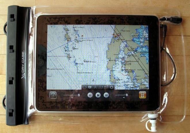
As most of these devices are not waterproof, or even water resistant beyond a sneeze, we buy waterproof cases for them. We have been using the LifeProof brand with great success, with no issues or failures to date. We have not tested the cases by submersion, but they have proven rain and spray-proof to date. When the touch screens get wet, particularly with salt spray, they become difficult to use. When this happens we just wipe the screen with a dry rag and carry on. For use at night, most of these devices’ screens are too bright, even on their dimmest setting. In this case, look for a set of features usually called ‘accessibility’. Designed for people with visual impairments, these will usually allow you to reverse or manipulate the colour palette on the screen, making it easier to use at night.
It’s also important to find a ‘home’ aboard for these devices. We know of one boat where a crew member sat on an iPad that had been left on a cockpit seat, rendering it useless, and another boat where the shelf it was stashed on was not secure enough, such that the tablet fell to an untimely demise in rough seas. We use a couple of different mounts for our iPads. We use an under-the-counter mount we bought in an Apple Store at the nav station and we also use a RAM mount suction cup device at the helm. These prevent the iPads from suffering an unfortunate fall and keep them ready to use. Under way, the iPads are secured in one or the other of these two locations.
You must also plan for a charging regime for these devices, and recognize that phone devices and tablet devices have different appetites for amps when charging. Phones will charge quite well and quickly on less than one amp, the typical output from a 12v USB charger or 12v USB socket you install, such as the ones available from Blue Seas. Tablets, with their larger batteries, may or may not charge on that output, and certainly will not charge quickly on that output. Tablets want an output in the two amp range to charge at their normal rate. 12v adapters that output two amps are available, but not as widely as the 500 ma or 1 amp variety. Make sure you get one of the two amp variety for charging a tablet.
We use the iPads and iPhones for a number of boat specific tasks: navigation, weather forecasting, cruising guides / sailing directions, storing and reading manuals for boat related equipment, reading sailing magazines, and so on, and we also use them for email, general Internet browsing, translation, local knowledge, and entertainment.
Navigation
We use a number of apps for navigation, with our favourite being Navionics. We prefer Navionics for its ability to allow users to input data such as anchorages, trail heads, rocks, soundings, lights, buoys, etc. using the community edits feature. Navionics also allows users to record sonar tracks and upload them when connected to the Internet, updating charts with newer data. In the Sea of Cortez, where the soundings for most cruising areas were last done over 100 years ago, this can make quite a difference.
Since navigation apps and their associated charts are quite inexpensive compared to paper charts or chart plotter chips, and it’s easy to run multiple applications and switch between them, we do have others and often compare and contrast for a given area, harbour or anchorage. Different app developers and chart producers have different schedules for producing new charts, so often one will be newer or more up to date than another. Other apps we use include iNavX, Garmin’s Bluechart, and iSailor. For example, we were recently in Guaymas, where Bluechart was clearly superior in its display of newly installed aids to navigation, whereas at Isla San Francisco (where we were at the time I wrote this article), Navionics or iNavX (with the blue latitude chart package) were clearly better.
While it is annoying to learn the multiple user interfaces for the different apps, the availability of the different chart sets makes it worthwhile. When using Navionics we frequently add data to the community layer, mostly waypoints, soundings and hazards. These are immediately available to us on the iPad we enter them on, and become available on our other devices (and the devices of other users who enable the community data layer) after we connect to the Internet and upload them to Navionics. This feature mimics what we did in days of yore, borrowing other cruisers’ charts and sitting with pencil in hand to copy over their notes to our charts.
There are hazards associated with the exclusive use of electronic charts, particularly vector charts. Especially when traveling longer distances, certain zoom levels of vector charts will not display notable hazards to navigation, such as islands. If available, raster charts should be sought out for longer voyages. Tom Cunliffe recently published an article in Yachting magazine about the hazards of relying solely on vector charts that is well worth a read. I previously wrote an article on the Navionics charts for Currents that has more information.
Some of these apps (notably iNavX) have the ability to integrate with other navigation devices like AIS sets, but most are pretty well stand-alone. For full on integrated chart plotting, only the new class of multi-function devices (MFDs) will do. They will integrate engine readouts, radar, AIS, chart plotting, depth sounders, scanning sonars, visual and infrared cameras, tank monitors, battery levels and much more. Using apps from the various MFD manufacturers, their displays and in some cases controls can be run from tablets or phones, allowing you to mount the MFD below, and access its data and functions remotely from anywhere aboard – the cockpit or deck, your berth, wherever via a wifi or Bluetooth connection. We use this on Avant to get the radar display and AIS plotting into the cockpit when required. The battery drain of these rich applications is quite fierce, so we need to keep a closer eye on the tablets’ battery capacity when we’re using these features.
There are also PC mirroring apps (such as VNC viewer) which allow you to see the screen of your PC on your tablet. These are useful if you use OpenCPN or another PC based navigation program, and allow you to remotely access and manipulate the PC via wireless.
There are also AIS apps for the iPad, which use shore stations to pick up boats’ AIS signals and aggregate them for users to view via the Internet. While not “real” AIS, these have some limited utility in looking for your friend’s AIS signal to determine where they are when out of range of your radio or AIS receiver. MarineTraffic and ShipFinder are the two we have tried. The most recent version of MarineTraffic seems harder to use than its predecessors, but both apps allow you to do basically the same thing, look for boats you know. I would not suggest either is a replacement for an AIS receiver or transceiver aboard, but they do have their uses. To avoid purchasing these you can simply use their websites for free on your device.
Another useful app is Ovitalmap. From China, with poorly written instructions and a so-so user interface, it is quite simply a way to download Google Earth images for offline use. Sit down, look at an area with the app, and then you can see the same imagery off line later from the cache the app keeps. Very useful, integrated with GPS, and easy to use. Google Earth itself does not cache much of anything on handsets or tablets, so this is a way to keep some specific, useful satellite images to view when offline.
Weather
We use a number of Internet resources and programs for weather. Our go-to app for gribs is Weather4D Pro. It allows you to select an area and the weather parameters you wish to receive and download them directly from the Internet, or request them via email, XGate or Iridium Mail. When displayed, the app allows you to manipulate and display the data in various ways, and animates the replay of the data. It also has a “zoom in” feature that shows spot data interpolated for a specific point (for example, your location), and shows your position on the chart with a blue dot. It also has a weather routing function, allowing you to import route data from another app and calculate a weather routed course (to use the weather routing, you must add a companion app ‘iPolar’ to calculate your performance polars).
We also use WeatherTrack for gribs, but find that the less-rich data set and user interface make it less useful.
An odd, but very useful app is AeroWeather. AeroWeather is designed for airplane pilots, and gathers weather data from airport weather stations you select and displays their weather (visibility, cloud cover, wind strength and direction). By selecting an appropriate range of stations, you can gain valuable insight into the pressure gradient for a given locale, and get weather data that is typically more up to date than most weather sites present (airports update every hour).
We use two main tide prediction apps, Shralptide and AyeTides. Shralptide is free, has an easy to use user interface, and is usually good enough. But ShralpTide’s tidal station database is small, and it only predicts tides up to 5 days in advance. If we want more granular tidal data than it provides, we go to AyeTides, with its richer data set and longer range forecasts.
Other weather apps used include WindAlert, PassageWeather, Weather Underground, and HF FAX (HF FAX ‘listens’ to our SSB and draws weatherfaxes, Sat images, etc. as broadcast). We also have created direct links in our browser to ASCAT for satellite wind reports, NOAA Mexico text forecasts, Geary’s Sonrisa Net forecast, and several of the pages on the Sarana website. Of course, most of this data is only available when connected to the Internet via wifi or a cellular network. Weather4D does cache downloaded gribs so they can be reviewed later, a very useful feature.
Cruising Guides / Sailing Directions
We load NOAA or DMA / NGIA produced coast pilots and sailing directions on our iPads for immediate use in the iBooks reading app. They’re free, and available on the Internet at link: for NOAA coast pilots and link: for DMA/ NGIA pilots and sailing directions. They make a nice adjunct to popular cruising guides, and often highlight land features omitted from coastal cruising guides, which tend to focus on places you stay (anchorages) and omit places you pass by between them. As with any electronic book, they are searchable within the reading app, making finding what you want a snap.
Boat Manuals and Reference Books
We also make a point of downloading boat manuals for as much of our equipment as we can find and storing them in the reading app. Most are downloaded with odd file names like svt200412opman-2.pdf, so we rename them appropriately for easy access. As with the guide books, they are easily searchable, making them easier to use. We also load Bowditch and a few other books we find useful for reference (where there is no doctor link: , where there is no dentist link: Mariners weather handbook link: , surviving the storm, link: , Ashley book of knots link: , etc.).
Translation
There are number of translation apps available, and many are free. Very useful when cruising in a foreign tongue. The Google translate app will also translate using the camera; point the app in camera mode at a sign or product package and it will translate it for you on the screen. While the translations are rough, and occasionally incomprehensible, they are usually enough to get the job done. Some translators require Internet access to work, and some download a basic vocabulary. Test apps with the device in airplane mode to see how they work without Internet access.
Local knowledge
There are a number of local knowledge and travel apps that are worth using. Most are free. Tripadvisor is useful, written primarily in English, and aimed at the traveler. It will list local restaurants, hotels, attractions or similar categories of things for you, with associated reviews by other travelers. Yelp and FourSquare are other location apps, primarily used by locals (so in Mexico the reviews tend to be mostly in Spanish). They will also help you find local businesses and provide reviews, for a wider assortment of businesses than Tripadvisor will (looking for a hardware store? Don’t bother with Tripadvisor).
Any of the location aware apps require a population of users with Internet capable handsets large enough to provide the reviews and list the businesses, so they are useful in large cities and bigger towns, and useless in small towns. They also suffer from much poorer location services in most of Mexico. In the USA or Canada, these apps will get you to the door of a business, but in Mexico they oft times will only get you to the neighbourhood, as the underlying cartography in Mexico is poor.
Entertainment
There are thousands, if not millions of entertainment apps for these devices. Soduku, solitaire, crosswords, chess, bridge — the possibilities are endless for idling away watches or bad weather days at anchor (although it is far more useful to employ those hours composing articles for Currents!).
A few of the entertaining apps we enjoy are planetarium apps like sky rover or distant suns, which help you identify the stars. I will also place in this category the Weems and Plath ship’s clock app with ships bells, which rings the traditional eight bell sequence of the navy watch.
This article has been provided courtesy of the Bluewater Cruising Association.
If you want to link to this article then please use this URL: www.sailworldcruising.com/150212