Hurricane Irma on its way to the Bahamas as a Category 5 Hurricane
by Weather.com on 7 Sep 2017
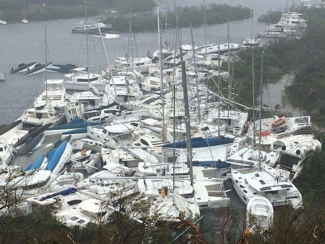
West end of Paraquita Bay, Tortola half way through Irma. Back side of eye yet to pass. Glenn Ashmore
Hurricane Irma, a potentially catastrophic Category 5 hurricane, is now full speed ahead for the Bahamas and Turks and Caicos before posing a serious threat to Florida and parts of the Southeast beginning this weekend.
(More:
Hurricane Central |
Impacts In Caribbean)
Below is everything we know about Irma right now, including its latest status, along with potential forecast impacts in the U.S. and the Caribbean Islands.
Irma's Latest Status, Timing
The center of Irma is located less than 340 miles east-southeast of Grand Turk Island and is moving west-northwestward at about 16 mph.
Irma's maximum sustained winds are steady at 185 mph based on data from NOAA and Air Force Hurricane Hunter aircraft, now for an astounding 34 hours.
(More: Irma's Notable Extremes)
Irma is pulling away from Puerto Rico, and is expected to graze the Dominican Republic and Haiti on Thursday. A sustained wind of 55 mph with a gust to 70 mph was reported at an observing site in San Juan Bay, Puerto Rico on Wednesday evening.
Hurricane warnings have been issued for parts of Puerto Rico, the northern coast of the Dominican Republic and Haiti, the southeastern and central Bahamas and the Turks and Caicos Islands. This includes Vieques and Culebra.
Additionally, a tropical storm warning is in effect for the southern coast of the Dominican Republic from Cabo Engano westward to the border with Haiti and for the coast of Haiti from south of Le Mole St. Nicholas to Port-Au-Prince. A tropical storm warning is also in effect for the Cuban provinces of Guantanamo, Holguin and Las Tunas.
A hurricane watch is also in effect Cuba from Matanzas Province eastward to Guantanamo Province and the northwestern Bahamas.
Low wind shear, increased mid-level moisture and increasing oceanic-heat content favor that Irma will remain a powerful hurricane (Category 4 or stronger) for the next several days, though some intensity fluctuations are likely at times. At this intensity, small deviations in wind speed will not change impacts. A direct hit will be catastrophic.
Given the robust nature of Irma's structure, it is possible that it will retain strength longer than currently expected, potentially into the Florida Straights as a Category 5.
Irma has been a Category 5 hurricane for more than a day and a half, which ranks it as the seventh longest lasting Category 5 in the Atlantic basin, according to Dr. Phil Klotzbach. Irma could take a run at the longest lasting Category 5 hurricane by Friday.
For the next three days, Irma will move west-northwest on the south side of a ridge of high pressure called the Bermuda high, centered in the central Atlantic.
(Interactive MAP: Track Irma)
By this weekend, Irma will begin to turn north in the direction of a departing southward dip in the jet stream that will set up in the eastern United States. Where that northward turn occurs will be critical for what impacts Irma may bring to parts of the southeastern United States.
Here's a general overview of the timing for impacts from Irma into this weekend.
Potential Impact Timing
• Dominican Republic/Haiti: Thursday; tropical storm force winds will arrive early Thursday in the D.R. and midday Thursday in Haiti
• Turks and Caicos: Late Thursday-Friday
• Bahamas: Friday-this weekend; tropical storm force winds may arrive as early as late Thursday
• Cuba: Friday-this weekend; tropical storm force winds will may arrive as early as Thursday night
• Southeast United States: This weekend into early next week, beginning in south Florida Saturday
U.S. Forecast: Watching Florida, Georgia and the Carolinas Closely
While it is still too soon to narrow down specifics on the exact path of Irma's center and eyewall, it is becoming likely that a major hurricane strike on at least part of South Florida, including the Florida Keys, will happen this weekend.
As mentioned before, the vast majority of the forecast guidance indicates Irma will begin to turn more to the north sometime this weekend.
The strength and expansiveness of the Bermuda-Azores high over the Atlantic Ocean and the timing, depth and location of a southward dip in the jet stream near the eastern U.S. will dictate where and when that northward turn occurs.
(More: Why the U.S. Forecast is Uncertain)
According to the latest NHC forecast, the center of Irma may be very close to South Florida by Sunday morning, with conditions going downhill already during the day, Saturday and worsening for southwest Florida on Sunday.
Hurricane watches are likely to be issued on Thursday for portions of the Florida Keys and the Florida peninsula.
However, as the NHC reminds us, average errors in the track of the center of an Atlantic tropical cyclone 4 to 5 days out are between 175 and 225 miles, which can make a large difference in impacts.
(Latest: Governors Declares State of Emergency Ahead of Possible Hurricane Irma Strike)
For now, all residents along the Southeast coast and eastern Gulf Coast, including Florida, Georgia and the Carolinas, should monitor the progress of Irma closely.
Early next week, the possibilities range from the center of Irma being located a couple of hundred miles east of the Florida or Georgia coastline to being in western Georgia.
In addition, Irma's wind field will be large, therefore, dangerous surf and coastal flooding will likely exist throughout the southeastern U.S. coastline even well away from Irma's center by late week.
Forecast: Puerto Rico, Hispaniola, Cuba, Bahamas
Puerto Rico and the Virgin Islands
The eyewall of Irma, containing the highest, most destructive winds, and the hurricane's outer bands are now pulling away from Puerto Rico.
Tropical-storm-force winds (39-plus mph) will lessen their grip on the island territory during the early morning hours.
Additionally, a storm surge of 2 to 4 feet is possible along the northern coast of Puerto Rico, along with a storm surge of 1 to 3 feet along the southern coast of Puerto Rico.
Conditions should improve quickly by later Thursday morning.
Hispañola, Turks and Caicos, Bahamas and Cuba
Irma will likely pass near Hispañola, the Turks and Caicos, the Bahamas and Cuba late this week into the weekend as a major hurricane.
Go here to keep an eye on the weather for more information and to read this in full
(More: Beware 'I' Hurricanes)
If you want to link to this article then please use this URL: www.sailworldcruising.com/157045