Prepare now - Maria on collision course
by Weather.com on 20 Sep 2017
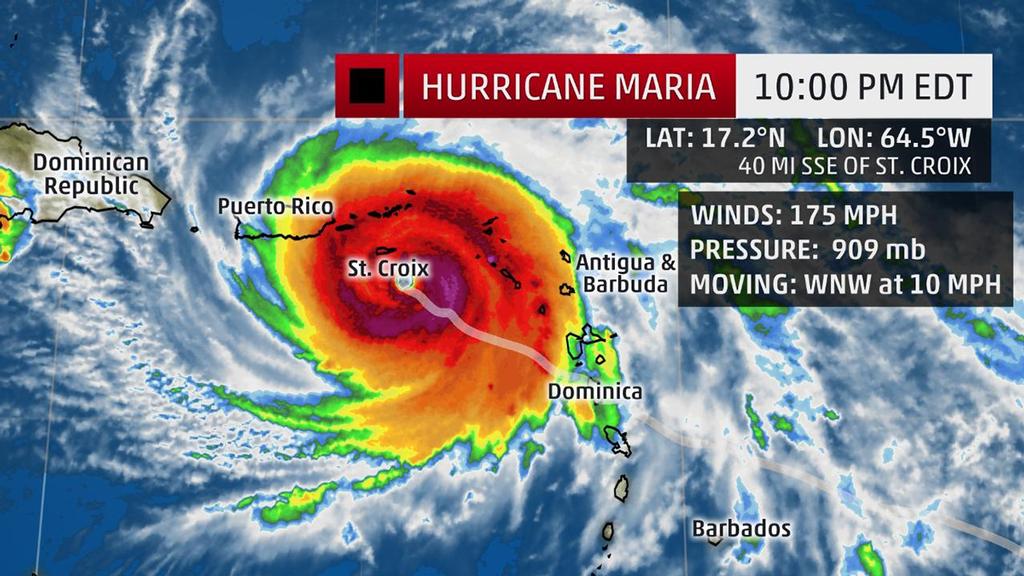
Current Storm Status - The highest cloud tops, corresponding to the most vigorous convection, are shown in the brightest red colors. Clustering, deep convection around the center is a sign of a healthy tropical cyclone. The Weather Channel
Hurricane Maria, a Category 5 on the Saffir-Simpson Hurricane Wind Scale, is closing in on a potentially catastrophic strike on the already storm-weary Virgin Islands and Puerto Rico, following a first-on-record Category 5 landfall for the island of Dominica Monday evening.
(More:
Hurricane Central |
Maria Lashes Dominica With 'Mind-Boggling' Devastation)
The National Weather Service office in San Juan, Puerto Rico, warned of 'catastrophic damage' from Maria's winds, as well as 'life-threatening rainfall flooding having possible devastating impacts' in a
hurricane local statement issued Tuesday evening.
Maria's center is currently located about 50 miles south-southeast of St. Croix in the U.S. Virgin Islands and is moving west-northwest at 10 mph.
A hurricane warning remains in effect for the U.S. and British Virgin Islands, Puerto Rico, Culebra, Vieques and in the Dominican Republic from Cabo Engano to Puerto Plata.
A tropical storm warning has been issued for Saba, St. Eustatius, St. Maarten, Guadeloupe, from west of Puerto Plata to the northern border of the Dominican Republic and Haiti and from west of Cabo Engano to Punta Palenque in the Dominican Republic.
A hurricane watch has been hoisted for the Turks and Caicos Islands and the southeastern Bahamas. Hurricane watches also include Saba, St. Eustatius, St. Maarten, St. Martin, St. Barthelemy and in the Dominican Republic from Isla Saona to Cabo Engano.
Maria rapidly intensified Monday thanks to a combination of low wind shear, a moist atmosphere and warm ocean temperatures.
A report from a U.S. Air Force Reserve Hurricane Hunter mission Tuesday evening confirmed Maria was still strengthening as maximum sustained winds increased to 175 mph and central pressure dropped to 909 mb, a lower pressure than Irma had at any time.
This is the lowest pressure for any Atlantic hurricane since Hurricane Dean's 905-mb minimum central pressure in August 2007. It is also the 10th-most-intense hurricane in Atlantic Basin history, based on minimum central pressure.
Next up for Maria is a potentially catastrophic strike on the Virgin Islands and Puerto Rico.
Puerto Rico, Virgin Islands, Hispañola Impacts
Weather conditions are rapidly deteriorating on the Virgin Islands, with a wind gust of 72 mph recently reported at St. Croix in the U.S. Virgin Islands.
Time is quickly running out for Puerto Rico before conditions go downhill there, as well. Residents and visitors should rush their preparations to completion immediately.
Some outer bands of showers are pushing through Puerto Rico, and steady rain is now soaking the Virgin Islands.
Maria will bring a potentially catastrophic combination of storm-surge flooding, destructive winds and flooding rain to Puerto Rico and the Virgin Islands as a Category 4 or 5 hurricane Wednesday.
'Locations may be uninhabitable for weeks or months,' according to the National Weather Service in San Juan, Puerto Rico.
Tropical-storm-force winds are currently spreading over the Virgin Islands, with hurricane-force winds arriving Tuesday night continuing into Wednesday morning, particularly in St. Croix.
In Puerto Rico, tropical-storm-force winds will arrive later Tuesday evening, with hurricane-force winds arriving by the pre-dawn hours Wednesday continuing into Wednesday evening.
Portions of the Dominican Republic, particularly near the north coast, may see hurricane-force winds develop as soon as Wednesday evening continuing into Thursday. There is still some uncertainty, as any slight jog of the eyewall north could keep the most intense winds off the coast of the Dominican Republic.
A storm surge of up to 7 to 11 feet above normal tide levels is expected in the British Virgin Islands, with 6 to 9 feet of storm surge possible in Puerto Rico and the U.S. Virgin Islands.
In the hurricane warning area of the Dominican Republic, water levels may rise by as much as 4 to 6 feet above normal tide levels, with a storm surge of 1 to 3 feet possible elsewhere along the northern coasts of the Dominican Republic and Haiti.
Puerto Rico may see 12 to 18 inches of rain, with locally up to 25 inches in some areas, through Thursday.
The Virgin Islands are expected to receive 10 to 15 inches of rain, with locally up to 20 inches.
The eastern Dominican Republic is forecast to pick up 4 to 8 inches of rain, with isolated 12-inch amounts.
These rainfall totals have the potential to produce widespread, life-threatening, potentially catastrophic flooding and mudslides.
Maria may be only the second Category 5 hurricane of record to landfall in Puerto Rico, joining the September 1928 San Felipe/Okeechobee hurricane.
Prior to Irma, only four other Category 4 hurricanes had tracked within 75 miles of central Puerto Rico in historical records dating to the late 19th century. Hurricane Hugo in 1989 was the last to do so, before Irma's Category 5 swipe just two weeks ago.
Leeward Islands Impacts
Hurricane Maria made landfall on the island of Dominica at 9:15 p.m. EDT Monday evening as a Category 5 hurricane with maximum sustained winds of 160 mph.
Hurricane-force winds may persist in portions of the hurricane warning area in the Leeward Islands Tuesday evening. This includes some locations in the northern Leeward Islands that were devastated by Hurricane Irma.
Additionally, bands of heavy rain on the eastern flank of Maria may wrap into these locations at times, accompanied by tropical-storm-force wind gusts.
A storm surge of up to 7 to 11 feet above normal tide levels was expected in the hurricane warning area.
High surf and dangerous rip currents are impacting the Lesser Antilles and will persist even for a day or so after Maria's center passes by.
Rainfall totals of 10 to 15 inches are possible in the central and southern Leeward Islands, with locally up to 20 inches in some spots. That has the potential to produce widespread, life-threatening flooding and mudslides, particularly on mountainous terrain.
Maria is also expected to produce 4 to 8 inches of rain, with locally up to 10 inches, over the northern Leeward Islands from Barbuda to Anguilla.
Two to 4 inches of rain, with locally up to 6 inches, can be expected in the Windward Islands and Barbados.
Will Maria Threaten the U.S. East Coast?
It is still too soon to determine at this time whether Maria will directly impact the East Coast of the U.S. next week.
Whether Maria will ever pose an East Coast threat will depend on steering currents in the upper atmosphere over the western Atlantic Ocean and the eastern United States that cannot be pinned down this far in advance.
Interestingly, the potential for Jose to stall off the Northeast coast this weekend could play some role in determining Maria's long-term future path. For more details, see the link below.
(More: How Jose Could Affect Maria's Long-Term Steering)
Also, if Maria interacts with the higher terrain of Puerto Rico and/or Hispañola, that could also affect its future track and intensity.
For now, all residents along the East Coast should monitor the progress of Maria.
Keep an eye on weather for updates in the days ahead for the latest details on Maria.
If you want to link to this article then please use this URL: www.sailworldcruising.com/157407