Seventh and Eighth blogs from on board Perie Banou II
by Jon Sanders on 28 Dec 2016
Seas off South Africa Jon has been enduring RPYC
Jon’s seventh Blog
Since last Wednesday, Perie Banou II has passed South of Madagascar. Dipping down on an angle from the Northeast. Passed 100nm South of Madagascar on non-stop route to Cape Town, South Africa.
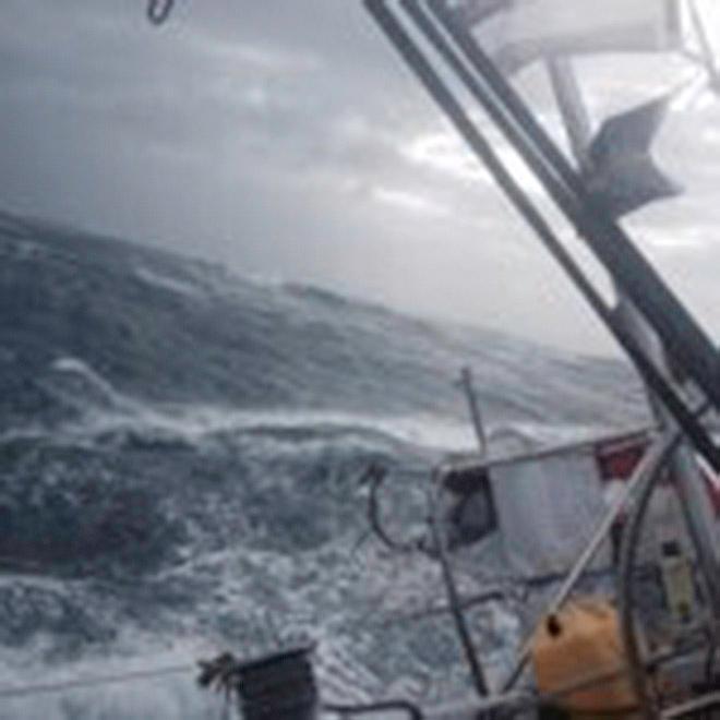
Approaching the Southern part of Madagascar and to the south of - the sea was sloppy. Even in zilch wind.
In this region 'you get that'.
Caused I suppose, by the very steep incline of the sea bottom, despite the favourable current. (Or the mountains under the sea).
It kinda makes this older specimen start getting younger and fitter! Forced by the compulsory isometrics of the situation. (The yacht is going every which way).
Interesting. Long, long way elsewhere is Cape Horn at 56 degrees latitude south.
I have cleared that Cape 5 times solo. Never in summer. (Nor in winter).
Coming to and at Cape Horn have copped terrific, incredible gales and storms.
I have also been becalmed. Same place. Grey forbidding cliffs, snow-capped mountains and a grey, cold oil calm sea. In other words, when the gale stops the sea calms quite quickly.
Sir Robin Knox-Johnson says more people have climbed Mount Everest than sailed yachts around Cape Horn.
Blimey, I don't want to climb Mount Everest, I would avoid climbing a hill on Australia's Nullabor Plain. I'm useless.
Anyway ahead of me is the Cape of Storms. (Cape of Good Hope).
The Cape of Good Hope is not the most southerly point of Africa. It is, in fact, Cape Aghulas.
South of Cape Aghulas (and that southern portion) is the Aghulas Bank. A wide bank. The southern end is 120 Nautical Miles distant.
The edge of the bank is the 100 fathom line. (A fathom is 6ft in proper language). Want to know what that is in meters? 'Buy a calculator'.
In the north between Mozambique-Africa and Madagascar, sweeping south, is the Mozambique Current.
My paper chart says 1 to 4 knots. The current follows the African coast, broadens and is joined by currents from the North West, (the direction I am coming from) and is renamed 'Aghulas Current'. Flows at 1 1/2 to 4 knots, and 2 1/2 to 3 knots.
I am steering to a 'way point' (I named St Francis) leads me to where I transit across the Aghulas Bank.
My US weather chart shows an increase in the potential for gales.
I have always fetched something rounding the bottom of Africa. This will be my 11th rounding.
The current doesn't help the wave formations and its ridiculous behaviour. To make things more awkward are ships, ships and more ships. All rounding the southern end of 'all of Africa'. Using the same track.
As always, I will be following the route recommended by my bible, the British Admiralty publication, 'Ocean Passages for the World'. (Sailing vessels section).
To quote Ocean Passages for the World, 'Keep in the strength of the Mozambique Current and the Aghulas Current. In rounding the Cape of Good hope, if west winds prevail, keep over the Aghulas Bank not more than 40 to 50 miles from the coast. Here the wind will be smoother than elsewhere.”
“It should be borne in mind that there is much less sea over Aghulas Bank in depths from 110 meters to 130 meters, or less, during gales than there is near the edge and south of it'.
Unquote there goes 400 years of experience. One would have rocks in the head to be off the South East end of the bank in foul weather. Seas there can break the back of a super tanker.
This 'Ocean Passages for the World' volume I have on board belongs to David Dicks. He reminds me now and again 'have you still got my book?' I see his notes within.
David in the 90s was the youngest to sail around the world solo without stopping. Age 17. He sailed his S&S 34 sloop named 'Seaflight'. (Jesse Martin and Jessica Watson followed).
All three sailed in S&S 34s. The yacht I am now sailing on is a 1971 built S&S 39. (Sparkman & Stephens).
Regards to all,
Jon
Jon’s eighth Blog
Hi all.
In my last blog I made mention of the Agulhas Current and the Agulhas Bank. I did.
Cape Town (Maritime) Radio carry warnings with their Ocean Forecasts. Give wind and predicted wave heights. Additional warnings for dangerous unpredictability in the Agulhas Current during westerly gales.
The electronic chart plotter has in small print (mid chart) 'Current Agulhas see lower zooms'.
Zoom in gives current direction, and 'the dangerous element in the navigation during and after gales'.
So one does not want to end up being in the Agulhas current during a westerly gale.
I was.
I had warning (via Cape Town Radio weather forecast). I put the third heavy weather reef in. Tied it 'as near as'. I checked all my halyards and everything.
Some days before I reorganised the forepeak department. Robin, Gareth, Vera and Colin would have been impressed.
The Almighty had other ideas. Reorganised the forepeak, turned it into a shambles.
In heavy weather I could liken the S&S34 and the S&S39 to putting a cork in a bottle, and if the bottle has lead on one side it will righten itself quickly. Everything is only as strong as its weakest link. I.E. Have a good mast section and go up one on the rigging wires (if not more) etc.
Rolly Tasker used to say to me 'Add more strength. Add more lightness. Add more simplicity.”
The radio mentioned 20 to 50 knot winds in forecast. I took the 50kts to be squalls. Nup. It seems to go 25 to 30. 30 to 40. And then 40 to 50. If you had to choose between 40 to 50 in the Aguhlas Current, or a Siberian Salt Mine (Both is unthinkable).
Jonathan Clough installed all my B&G equipment. He also installed a brand new VHF Aerial on top of the mast and a vertical aerial on my back rail. To that aerial I tied Royal Perth Yacht Club General Manager’s (Stuart Walton) Club Burgee. The aerial went from vertical to horizontal. The Burgee remained, trying to flay itself to pieces.
There is no shortage of electricity on this yacht. Especially in foul weather. The batteries being fully topped up. One can turn on all sorts of power, as much as I want. The 'Superwind' generator with its 3 carbon fibre blades pumps the energy thru. The silent giant keeps the power going.
The gale did a bit of good. Cleaned the decks. A brilliant wash down. (Specially the cockpit). To hove-to I put the (storm) third reef in to the mainsail, and set the self steerer to hold the yacht 50 degrees into the wind and boiling steep sea. Any angle into the oncoming sea is good. (Beam on one could find oneself walking on the roof).
Xmas day came and went. The wind was mild, the sea lumpy. The food remaining in my locker boring. Very boring. But Jon Readhead, and his super nice wife left a Xmas package on board. 'Walkers' - bit elite - Rich Fruit Cake and Scottish short bread biscuits. That will do. Par excellent.
Jon is a Royal Perth Yacht Club member who works almost full time creating, making and recording Club Archives. I suspect Royal Perth Yacht Club have the best Archive records of any yacht club in Australia. Other clubs consult him.
In a few hours I shall clear Cape Agulhas. The most southern point in all of Africa. The sea and wind is mild. The Agulhas Bank seems to have lots of ships, oil rigs and odd fishing boats. They always seem to be where I want to go.
Kindest and best regards to all,
Jon
Notes from Robin
Jon is abeam Durban, located within the Eastern Cape of South Africa. To his port is the Transkei Basin (up to 4,500m deep) underlain by oceanic crust. To his starboard is the Agulhas Bank (50 - 200m deep) underlain by African continental crust. The topographic transition is called the Agulhas Ridge. This “ridge” lies along the eastern end of the 1,200 km long Agulhas - Falklands Fracture Zone (AFFZ) - one of the largest strike-slip fracture zones on planet earth and one attributable to the separation of Africa and South America.
This ridge is a prominent topographic feature ranging in height between 4,900 ft (1,500m) and 8,200 ft (2,500m) above the abyssal plain, notionally at 4,000m deep. Refer to this video at the 3:03 mark (freeze frame) to put this tectonic structure into global perspective. Here you will see the Mid-Atlantic Ridge (red line) do a major eastward step along the AFFZ. Follow the AFFZ eastward to near the edge of the image and it becomes the Agulhas Ridge.
The video above demonstrates the breakup of the supercontinent Pangea into Gondwanaland and Laurasia. It also demonstrates further breakup into the landmasses we observe today. Importantly, this video shows seafloor magnetic polarity reversals (black / white representations) of the vertically-emplaced basaltic magma sheets along mid-ocean ridges. This is how oceanic crust is formed. About 125 million years ago (0:22 mark) the AFFZ is initiated and its growth continues to this day.
These “Agulhas” namesakes make reference to Cape Agulhas (Cabo das Agulhas - Portugese), one of two famous African Capes rounded by Jon on numerous occasions. The other is of course the Cape of Good Hope (Cabo da Boa Esperança - Portugese) or Kaap de Goede Hoop (Dutch). The southernmost of these Capes is Cape Agulhas which literally translates to the “Cape of Needles”.
Cape of Needles? Ah… there must be columnar-jointed basalt or dolerite at Cape Agulhas? You know, the columnar-jointed dolerite seen in all the videos of race-leading yachts in the Rolex Sydney-Hobart Yacht Race as they round Tasman Island before entering Storm Bay. Black Jack: 2014 Rolex Sydney-Hobart Yacht Race; Here. And Comanche heading for line honours in the 2015 Rolex Sydney-Hobart Yacht Race (above: Rolex: Kurt Arrigo). But no! Around the year 1,500 AD, apparently, Portuguese sailors observed that the direction of MAGNETIC NORTH (compass needle) and TRUE NORTH (geodetic / geographic pole) coincided at this location; zero magnetic declination / variation. Hence the name…
There is, nevertheless, a major geological link between Cape Agulhas / the Eastern Cape of South Africa AND the Tasman Island / Storm Bay & Derwent River surrounds. The Tasman Island columnar pillars, seen as a backdrop to Black Jack and Comanche, are the result of slowly-cooled, intruded (formerly) molten basaltic magma - called dolerite sills. Hexagonal cooling joints form at right angles to the cooling surfaces - either at rock or air interface.
The rocks hosting these cooling joints are very extensive in eastern Tasmania. They occur on Tasman Island and in the upper parts of Mt Wellington, the backdrop to Hobart and the finish line. These are the Tasmanian Dolerites. The very same rocks, same linked geological process, same chemistry and same age, occur in the Eastern Cape and in close proximity to Cape Agulhas; the Karoo Dolerites. They also occur in India (the Deccan Traps) South America (the Parana Basalts - in southern Brazil) in Antarctica (the Ferrar Dolerites and Volcanics) and more…
At the time of breakup of Gondwanaland, in addition to the formation of basaltic ocean crust along nascent mid-ocean ridges, the same basaltic material was intruded along transform faults penetrating continental crust. The basaltic magma flowed onto the earth surface and intruded rock strata; resulting in basaltic flows, dolerite sills and dolerite dykes.
Jon, sailing across the Agulhas Ridge towards Cape Town, precipitated the above monologue on geology and precipitated the obtuse link to the 2016 Rolex Sydney-Hobart Yacht Race. As you watch the next race and see images of the lead yachts rounding Tasman Island, you may marvel at the geological significance of those dolerite columns and what was initiated on our planet approximately 160 million years ago. Yes, “initiated” is the correct verb. The process is continuing right now…
Jon should be in Cape Town fairly soon. Maybe not in time for Christmas but likely in time for the start of the 2017 Cape2Rio Race hosted by the Royal Cape Yacht Club. He will traverse the Agulhas Bank in order to reach the RCYC. Adjacent are the deep ocean basins and associated ocean currents. The South Atlantic Current and Benguela Current (clockwise, north-flowing) meet the South Indian Current and Agulhas Current (counter-clockwise, south-flowing) on the Agulhas Bank.
These currents clash near the surface forming vortices that are kilometres across. They clash to the south and at depth where the Antarctic Circumpolar Current dominates. Consider also, wind forcing (possibly gale force), tides (possibly contrary) and at depth, the affect of temperature (thermocline) and salinity (pycnocline) boundary layers and their interactions. Now insert the AFFZ, the Agulhas Ridge and continental slopes as topographic boundaries to this mix. Given the AFFZ is active and has active subsurface volcanoes, add sustained bursts of heat energy, various abundant volatiles and particulates (including sulphides) to this mix. Interesting…
We will likely have Jon provide information on conditions at the surface of the Agulhas Bank, as he rounds the Capes, in his next blog.
Jon sailing across the Agulhas Ridge and this discussion of Gondwanaland in the week before Christmas 2016 has brought images of amethyst to mind; especially the spectacular amethyst geode / amygdule found in the Brazilian state of Rio Grande do Sul.
Amethyst: from Latin amethystus, from Greek amethystos 'amethyst,' literally 'not intoxicating”.
Just about anywhere in the world you find a jewelry shop it will likely have, on display, amethyst amygdules from Brazil. They range in size from one you could conceal in your hand to something you would need to move on the back of a large truck. The amygdules form within surface basaltic lava flows. The lava and amethyst range in age from 120 to 130 million years - the age of the Parana Basalt from which these specimens are extracted. Lesser quantities of amethyst are also extracted from the Karoo Dolerites. Whilst amethyst is found in other geological environments it is the Parana Basalt variety that dominates.
The next time you encounter an amethyst amygdule, think Brazil, Rio Grande do Sul, the breakup of Gondwanaland, 120 million year old rock - and Jon’s 10th circumnavigation of planet earth!
For Jon & Perie Banou II: Merry Christmas! Enjoy that Christmas cake stashed on-board just before you departed Fremantle. Maybe there is a flask of “amethyst” rum also stashed on-board for the occasion?
_ Robin Morritt _
If you want to link to this article then please use this URL: www.sailworldcruising.com/150735