
Passage weather
by Max Shaw / Sailing Yacht Fluenta 6 Jan 2019 05:22 UTC
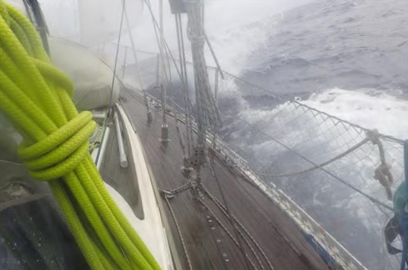
Squalls on the way to Tuvalu two years ago (Victoria photo) © Island Cruising NZ
Our next planned passage is from Fiji towards Majuro. Since we are far behind our intended schedule we will try to do it in one single passage but keeping options open for a stop in Tarawa if it appears prudent.
The passage is about 1600 nm down the rhumb line, starts in an active cyclone zone, crosses two convergence zones and two tradewind belts so there are some complexities.
We have been asked in the past how we assess weather windows so here is a brief blog post on how we look at the weather to decide when to go.
Strategic view
As we plan our seasons we first consider how to avoid tropical revolving storms - cyclones in the South Pacific or what we would call hurricanes at home. We try to not be in the cyclone zone during the season (rather unsuccessfully this year). Like most things in nature, the "season" does not have a strict start and stop but rather increasing and then decreasing probabilities of cyclone formation.
From there we look at the likely winds and other conditions to be encountered along the desired route. There are various sources for this:
- Pilot charts - These are available for free from the US Government and show the average winds and directions and ocean currents as well as probabilities of gales or calms for each month of the year. Open CPN also has a great plug-in to display much of the pilot chart data overlaid on your charts.
- Jimmy Cornell's Ocean Atlas - This is a commercial product we have that is a refinement of the government pilot charts specifically for crossing oceans by sailboat.
- Noonsite usually has good country by country weather information as well.
- Finally, we look at the previous year's weather with some historical grib data. With qtVLm we can even simulate doing the route using actual weather data.
The degree of analysis depends on our assessment of the risk. If we are heading downwind in the trades in the cruising season such as our recent sweet run from Tonga to Fiji we will not do much research. This upcoming passage receives a bit more analysis, and the potential trip to Alaska next year receives a lot of consideration !
Tactical
As the desired departure time draws closer, it is time to start watching the weather patterns. Again, the perceived level of risk drives how soon we start and how hard we look. Generally for the bigger passages we try to start a month ahead to get a feel for the weather patterns.
To "watch" the weather, we primarily use GRIBs downloaded over the internet if feasible/available or on our Iridium Go. Depending on the area we are hoping to sail through, we also use weather maps or weather faxes to give us a better understanding of what is going on. These maps are produced by the national meteorological agencies and are produced by actual meteorologists rather than just the output of a computer model like the GRIBs. They are also labelled making it easier to understand where the frontal systems and convergence zones are located.
We download and view GRIBs with Predictwind Offshore. We have used a lot of different software packages over the last almost ten years (over six in Fluenta and then STV Tuna prior to that) but Predictwind Offshore has been our favourite over the last two years. It gives access to:
- Four different weather models: the usual GFS model and the European ECMWF model, as well as two proprietary Predictwind modes. We find having multiple models gives us an insight into the reliability of the forecast (i.e. do the models agree?) and shows multiple possible outcomes so we can get a heads up if there is an increased possibility of something unpleasant occurring. While the GFS model is free to the public, the ECMWF model is only available through paid services such as our Predictwind subscription. In our experience this model has been the most reliable in the areas we have been sailing.
- Wind and Waves: Wind is of course rather important to a sailboat but it is the waves and their direction and period that can make us really miserable
- Convective Energy (CAPE or convective available potential energy): CAPE is an indicator of the instability of the airmass. We find it useful as an indicator of the location and intensity of the convergence zones. If you look at the winds in a convergence zone, you will notice that light winds are forecast. The reality though, is usually mostly light winds interspersed with significant squalls and electrical storms. Not really fun sailing or motoring!
- Currents: Beyond the effects of the tidal streams, there are significant ocean currents swirling about on the open seas. Even a 0.5 kt current makes a significant impact when you average six knots boat speed.
- Precipitation: At first it may seem like this is a funny thing to be concerned about, but the rain forecasts are a great way to see where the frontal systems are expected to be. While weather faxes have the fronts drawn on them, the GRIBs do not show the frontal systems. With the rain forecast data, the front locations can be inferred.
- Routing: For long passages I used to look at the weather along our desired route by marking our expected locations for each day using our average daily runs and then using a spreadsheet to record what winds we could expect at those times and locations. This is far less tedious now with the routing function on Predictwind Offshore. I input the start and finish positions, set our minimum winds before switching to motoring, and press "download". The routing is then done on the Predictwind server using the highest resolution wind, wave and current data and the end results are sent back to us in a small file (approx 6 kb). The forecast weather data and expected boat speed, direction and location can then be viewed on the chart, in tabular form or on a graph. I have not done a "how to" on this as it is covered in the Predictwind website far better than I could ever do.
For more complicated routes we also have used a weather router. Our favourite weather guru is Bob McDavitt or Met Bob. He is very knowledgeable with an excellent understanding of the South Pacific weather after decades covering the weather of this area. He is also very affordable and you can tailor the services based on how much support you want. We have used him for six passages between the tropics and New Zealand and our last trip from the South Pacific to the Marshall Islands and back. With any router it is important to do your own assessment first so you can look at the recommendations with a critical eye.
Further, you should be cognizant of the time delays in working with a router i.e. the data the routers use for their assessment may be quite dated by the time you actually download the email. This is another reason you need to be able to download your own data and do your own routings and risk assessments in a timely manner. So, does one need a router? Absolutely not, but it is another tool to help increase the probability of a good passage. It is also nice to have a router available if you have a problem or the weather does not cooperate. The router is sitting in a dry stable office with real internet, a big screen, years of experience and is not likely to be sleep deprived or sea sick.
Enroute
Finally, after patiently waiting for a "good enough" window you are at sea on passage. Whew. Once under way I download weather twice a day. With the Iridium Go and unlimited data, we can be a lot more greedy downloading weather data than we were when we relied only on the SSB radio. The routing is analyzed back at Predictwind's server so it is done with the best available data. Even so, it is nice to have an overall picture so we download the forecast weather for the remaining time of the passage as well. The ocean current data is quite data intensive so it is nice that the ocean currents are incorporated into the routing.
Keeping up to date with the weather allows us to, at a minimum, mitigate the effects of undesirable weather. We can try to avoid winds that are going to be too strong or too light. In areas of forecast calms we can decided whether it is better to drift, sail slowly or motor, depending on what is forecast to happen after the calms or where and when the winds will fill in. In the the tropics we will normally continue to sail as long as the sails are drawing. Conversely, between New Zealand and the tropics, if the winds are calm it usually means the weather is just taking a break before it gets awful, so we will motor to maintain a minimum speed and reduce our risk exposure.
The forecasts also allow us to look at options for diversions. For example, earlier this season sailing from New Zealand to Tonga we were mentally committed to pushing on to Tongatapu regardless of the headwinds. However, when we looked at our options, it was clear that a diversion to Minerva Reef and two good nights of sleep anchored there would allow for better weather on the way to Tonga and only delay our actual arrival into Tonga by one day. If the conditions are not matching the GRIBs we also have the option of contacting our weather guru to get his take on the weather. We also can use the weather fax or download the Fleet Code to get another view. Finally, do not forget about the old school methods of looking outside, Buys Ballots law and checking the barometer...
...and sometimes it is just nice to be in the calm at anchor.
This article has been provided by the courtesy of Island Cruising NZ.