
Hurricane Lorenzo is one of the strongest hurricanes so far east in the Atlantic
by Jonathan Erdman 29 Sep 2019 01:54 UTC
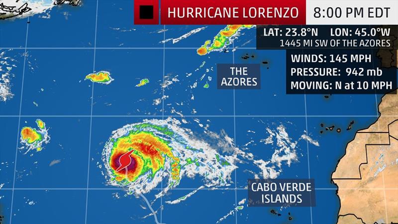
Current Storm Status - The highest cloud tops, corresponding to the most vigorous convection, are shown in the brightest red colors. Clustering, deep convection around the center is a sign of a healthy tropical cyclone © weather.com
Hurricane Lorenzo is once again one of the most intense hurricanes so far east in the Atlantic Ocean, and poses a danger to the Azores and possibly the U.K. next week.
Lorenzo rapidly intensified into a Category 4 hurricane Thursday, with maximum winds estimated at 145 mph, but had temporarily weakened to a Category 3. Lorenzo is once again a Category 4 with winds of 145 mph.
According to Dr. Phil Klotzbach, a tropical scientist at Colorado State University, Lorenzo is the most intense hurricane east of 45 degrees West longitude in the historical record.
In addition, Lorenzo has been a major hurricane for the longest period of time east of 45 degrees West longitude on record, according to Klotzbach.
Lorenzo Forecast
The storm is no immediate direct threat to land, but it is forecast to pass near the Azores Tuesday night or Wednesday as a weaker, but still formidable hurricane.
Lorenzo will bring higher surf to much of the Atlantic basin, including the northern shores of South America and most Caribbean islands, Bermuda and may even bring higher surge to parts of the East Coast over the next few days.
To read more please go to the original article.