
OCC Roving Rear Commodore report from the Caribbean
by Alastair Hill 30 Oct 2019 14:16 UTC
Eastern Caribbean map © Alastair Hil
Sailing southbound in the Windward Islands in the Eastern Caribbean during the winter is our favourite direction; with the trades normally blowing from North of East a southbound direction is usually off the wind and sheets can be eased somewhat allowing for a lovely beam or broad reach. Going the other way, however, can be a harder passage and we will often wait for a weather pattern that veers the trades to South of East and reduces their strength.
In addition to a better wind angle, there are times when a northbound passage can be assisted by getting a lift from the Antilles Current. This ocean current runs along the coast of South America from Brazil and sweeps northwestwards into the Caribbean Basin. The current runs strongest between Trinidad and Grenada, but is also felt in the passes between St Vincent and Grenadine Islands. The diurnal flood tide in the Windward Islands, although not very significant, tends to reduce the strength of the Antilles Current slightly, whilst the ebb tide augments it, especially during spring tides. So some consideration of the diurnal tide as well as the Antilles current can help (or hinder) your passage making.
The passage northwards from Bequia to Martinique is a hop of about 90 nautical miles. We usually do it as an overnight, leaving in the evening, but this time we elected to leave Bequia around 0200 hrs and planned to be in St Anne at the southern end of Martinique in the afternoon, so we could wind our way through the fields of fish traps that infest the tip of the island before darkness.
We expected the wind and sea conditions to be moderate, with about two-thirds of a full moon and hadn’t paid much attention to the currents until we cleared the tip of St Vincent when I noticed that our speed over ground was much better than usual for our single reefed main and slightly furled headsail plan. In fact we were often seeing SOG of over 10 knots! I checked the chartplotter-derived speed against the navigation programs on my phone and iPad and they were all in agreement. We did notice some areas of confused and larger than normal swells, especially approaching the southern tip of Martinique. Ultimately the passage took us about four hours less than planned and we arrived in the early afternoon.
After we got anchored and sails put away, I downloaded a GRIB file for the currents using the Weathertrack app. It then became clear as to why we had enjoyed such a fast passage….a strand of the Antilles current had shifted substantially Eastwards and was now running in a northerly direction up the East side of the island chain straight up to Martinique and we were lucky enough to have hitched a ride along the edge of it. I’m glad we weren’t going in the other direction as it would have been a tough slog fighting that current all the way.
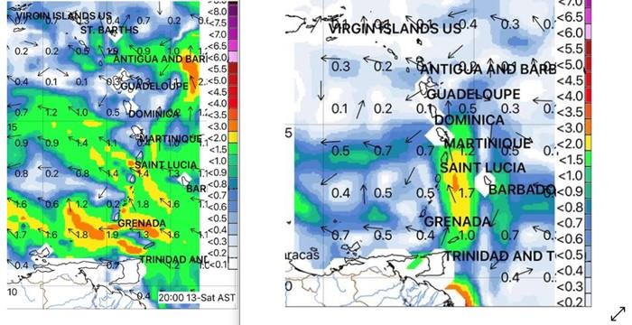
For a visual illustration of what we encountered, look at the screen grabs from the Weathertrack application below. The ‘normal’ location of the Antilles Current is seen in the first screen grab, with the strongest current located between Grenada and Venezuela where it approaches three knots. The second screen grab illustrates the conditions we encountered where a large North-South current plume developed between St Vincent and Barbados and extended all the way to Martinique. Weather track is a useful and easy to use application. To download ocean current GRIB files, I use the NOAA RTOFS model available in Weathertrack.
In future, we’ll keep a closer eye on the Antilles current when planning longer inter-island passages!
HF Radio Net Reminder: For OCC members and friends arriving for the first time in the E. Caribbean with the ARC, the OCC E. Caribbean radio net is a useful resource for obtaining local knowledge about anchorages, marinas, repair facilities and the like. It is also great for organizing social events and generally keeping in touch. The net operates on 6227 kHz USB at 0730hrs. New net controllers are always welcome!
This article has been provided by the courtesy of Ocean Cruising Club.