
Saildrone fleet completes first Arctic mapping mission
by Saildrone 16 Oct 2020 19:58 UTC
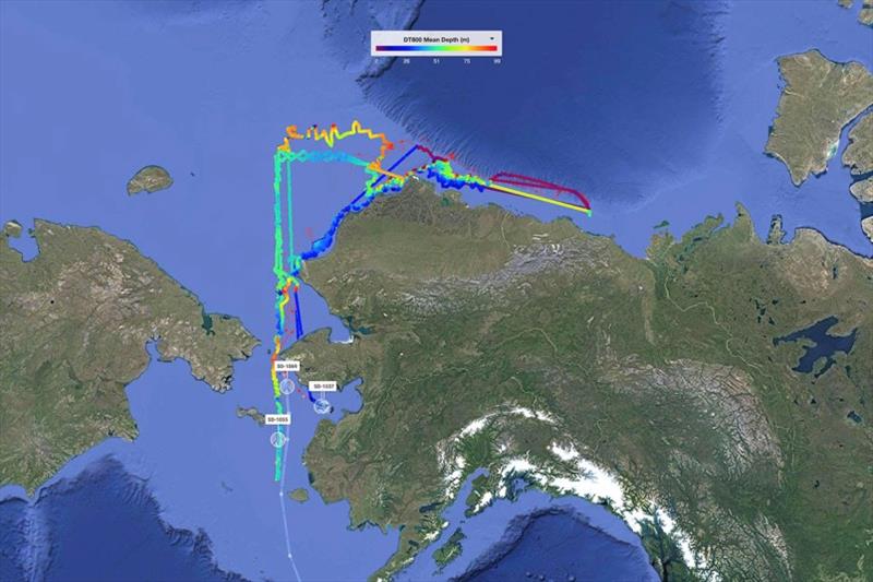
Four saildrones sailed 8,000 nautical miles round trip from San Francisco to the Canadian border to collect bathymetry data off Alaska's North Slope © Saildrone
A fleet of Saildrone wind and solar-powered vehicles sailed from San Francisco to the Arctic to perform an acoustic single-beam bathymetry mission supporting the National Oceanic and Atmospheric Administration (NOAA)'s effort to provide modern, accurate mapping data of the Bering Sea and Alaska's North Slope. Accurate bathymetry of the Arctic seafloor is key to maritime safety, economic development, and sustainability efforts in the region.
The objective of the mission was to identify the 20-meter and 50-meter isobaths (contour lines), delineating a virtual lane to be mapped for safe passage of commercial vessels and to demonstrate the ability to conduct remote bathymetric surveys using unmanned technology. The mission was operated in collaboration with TerraSond on behalf of NOAA's National Ocean Service (NOS) Office of Coast Survey (OCS). It is the first step toward resolving major gaps in the charts of the Arctic.
The ~8,000 nautical mile round trip mission took the Saildrone fleet across the North Pacific Ocean, through the Aleutian Islands, across the Bering Sea, through the Bering Strait, and across the Chukchi and Beaufort Seas to the Canadian border—and back. Saildrones operate autonomously, sailing according to set waypoints, though they are supervised 24/7 by managers located at Saildrone headquarters in Alameda, CA. Mission managers and stakeholders followed the data in near real time via the Saildrone Mission Portal and adjusted survey routes and plans to ensure that the saildrones were continually mapping the correct contours.
"The purpose of the Saildrone vehicle is to make ocean data collection cost-effective at scale, while not exposing humans to unnecessary risk. The north slope of Alaska is a cold and remote place that is hard to get to at the best of times but combined with the COVID-19 pandemic, it has been practically inaccessible for most of this year. However, our saildrones were able to access the area, map the required contours, and safely depart without human intervention. Sailing from California around Alaska to the Canadian border and back is an amazing voyage. Yet another demonstration of the robustness and utility of the Saildrone platform, in very challenging times," said Saildrone founder and CEO Richard Jenkins.
The saildrones were deployed in late May. After an approximately 11.5-week transit, they rounded Point Hope to begin the North Slope survey. They returned south through the Bering Strait in late September. On their way back to California, they are performing additional surveys in Norton Sound and Kuskokwim Bay.
"The completion of the summer mapping mission using saildrones is an achievement for all involved," said Rear Admiral Shepard M. Smith, director of NOAA's Office of Coast Survey. "This mission lays the groundwork for future mapping operations in not only the Arctic but other remote locations."
The vehicles also collected critical meteorological and oceanographic data throughout the mission. Early on, an issue with SD 1069's echo sounder was discovered. Mission collaborators opted to keep this vehicle with the fleet in the Arctic, and it spent approximately one month acting as a fixed ocean station some 70 nautical miles northeast of Point Hope. Collected metocean data was shared with weather forecasters in real time, and the raw data will be available to scientists and researchers to download from the Saildrone Data Explorer after the vehicles return to San Francisco.
Saildrone typically launches Arctic missions from Dutch Harbor on Amaknak Island in Unalaska, AK, however, due to COVID-19 travel restrictions, the vehicles were launched from San Francisco Bay. This is the second Arctic mission in 2020 to be launched from Saildrone HQ; three Saildrone USVs completed a 60-day acoustic survey of Alaska pollock in the Bering Sea on behalf of NOAA Fisheries' Alaska Fisheries Science Center. Those vehicles arrived safely back in San Francisco earlier this month.
Main photo: A heat map showing mean depth as measured by Saildrone's Arctic fleet during the 2020 mapping mission.
Resources: NOAA Office of Coast Survey, "Autonomous Vessel Operations in the Arctic: Lessons Learned from the Summer 2020 Mapping Mission," October 8, 2020